Thursday, September 18, 2008

Oronce Fine (juga dikenal sebagai Oronteus Finaeus) adalah seorang ahli matematika Perancis terkenal dan peta yang tinggal antara 1494 dan 1555. Dia terkenal atas peta 1531, yang ditemukan di Perpustakaan Kongres di Washington DC pada tahun 1960 oleh Profesor Charles H. Hapgood
Meskipun peta ini telah disalin dari sumber sebelumnya, apa yang menarik tentang itu menunjukkan bahwa non-glasial ketentuan costal wilayah Antartika, terutama Queen Maud Land, Enderby Tanah, Wilkes Land, Victoria Tanah (pantai timur Laut Ross) , Dan Marie poisonall Tanah.
Dari benua Antartika yang ditemukan pada 1818, dan pada tahun 1949 yang sebenarnya telah dipetakan landmass sebagai hasil survei seismik yang komprehensif dilakukan oleh gabungan Inggris-Swedia tim penyelidikan ilmiah. Menurut bukti geologi, Queen Maud Tanah terakhir es-gratis di 4000 SM. Tidak ada peradaban diketahui ortodoks sejarah yang memiliki kemampuan survei Antartik pantai di 4000 SM.
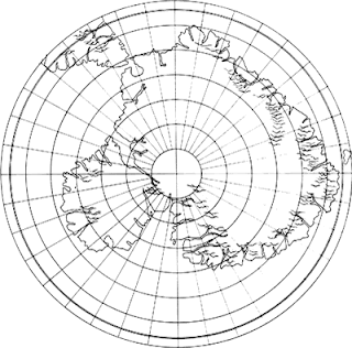
Charles Hapgood dan tim ini dikonversi dari peta aslinya proyeksi metode ke metode proyeksi yang modern. Lihat hasil di bawah ini.
Gambar pertama ini hanya sebagai peta itu digambar oleh Oronteus Finaeus.
Oronce Finé (also known as Oronteus Finaeus) was a renowned French mathematician and cartographer who lived between 1494 and 1555. He is famous for his map of 1531, which was discovered in the Library of Congress in Washington DC in 1960 by Professor Charles H. Hapgood.
Although this map has been copied from earlier sources, what's interesting about it is that it shows non-glacial conditions of the costal regions of Antarctica, notably Queen Maud Land, Enderby Land, Wilkes Land, Victoria Land (the east coast of Ross Sea), and Marie Byrd Land.
The continent of Antarctica was discovered in 1818, and in 1949 the actual landmass was mapped as a result of a comprehensive seismic survey conducted by a joint British-Swedish scientific reconnaissance team. According to geological evidence, Queen Maud Land was last ice-free in 4000 BC. There is no civilization known to orthodox history that had the capability of surveying the Antarctic coastline in 4000 BC.
Charles Hapgood and his team converted this map from its original projection method into a modern projection method. See the results below.
This first image is simply the map as it was drawn by Oronteus Finaeus.

Next they converted it to a modern projection method as shown below.

Bandingkan dua gambar pertama yang modern dengan peta Antartika hanya untuk melihat seberapa dekat mereka.
Compare the first two images with a modern map of Antarctica to see just how close they were.
.jpg)
Apapun beberapa teori sebagai ke bagaimana bisa ada peta, yang Oronteus Finaeus Peta tetap merupakan misteri.
Regardless of some of the theories as to how such a map could exist, the Oronteus Finaeus Map remains a mystery.


Post a Comment
0 Comments:
Post a Comment